Monday, February 28, 2011

Windy Tonight and Clearing through the Week

Post Frontal Conditions will be windy. Gusts around 25 mph are not out of the question at all through the night time hours. Winds this week should be calm from the North/Northwest, which will be good for drying Delta soils out. Southerly Flow always brings in moisture due to our situation with respect to the Gulf of Mexico, so anytime we can get winds out of the North and some sunshine the environment is much more efficient at drying the soils out. I'm going to also throw in a chance of Rain for Friday/Saturday; of course I'll refine that once we get closer but I don't want any of you to have surprises.

Nights this week will be chilly with Dry air in place and no clouds. Solar Energy can most efficiently leave the surface during nighttime hours when clouds are not present.

g13.2011059.1745_smUS_wv.jpg (600×448)

You can see the Dry Air (Labeled Orange) in place below the surface front on Water Vapor Imagery.

From this point forward and into the summer, forecasting will be much harder. Convection itself is not a difficult process to forecast, but exactly where it will happen is an extreme challenge. This is mostly due to the lack of observations that Meteorologists have on hand.


The points on the image above represent locations where Weather Baloons are launched. These observations are critical for forecasting. The Upper-Air network helps forecasters get a handle on the profile of temperature and moisture at a point. For Mesoscale (Small Scale) Forecasting (Mississippi Delta) , I basically have two tools at my disposal: The Jackson, MS observation and the Little Rock, AR observation. Common Sense can tell you that two observations are not representative of an area that spans hundreds of square miles. Why don't we have more observations? It is expensive.

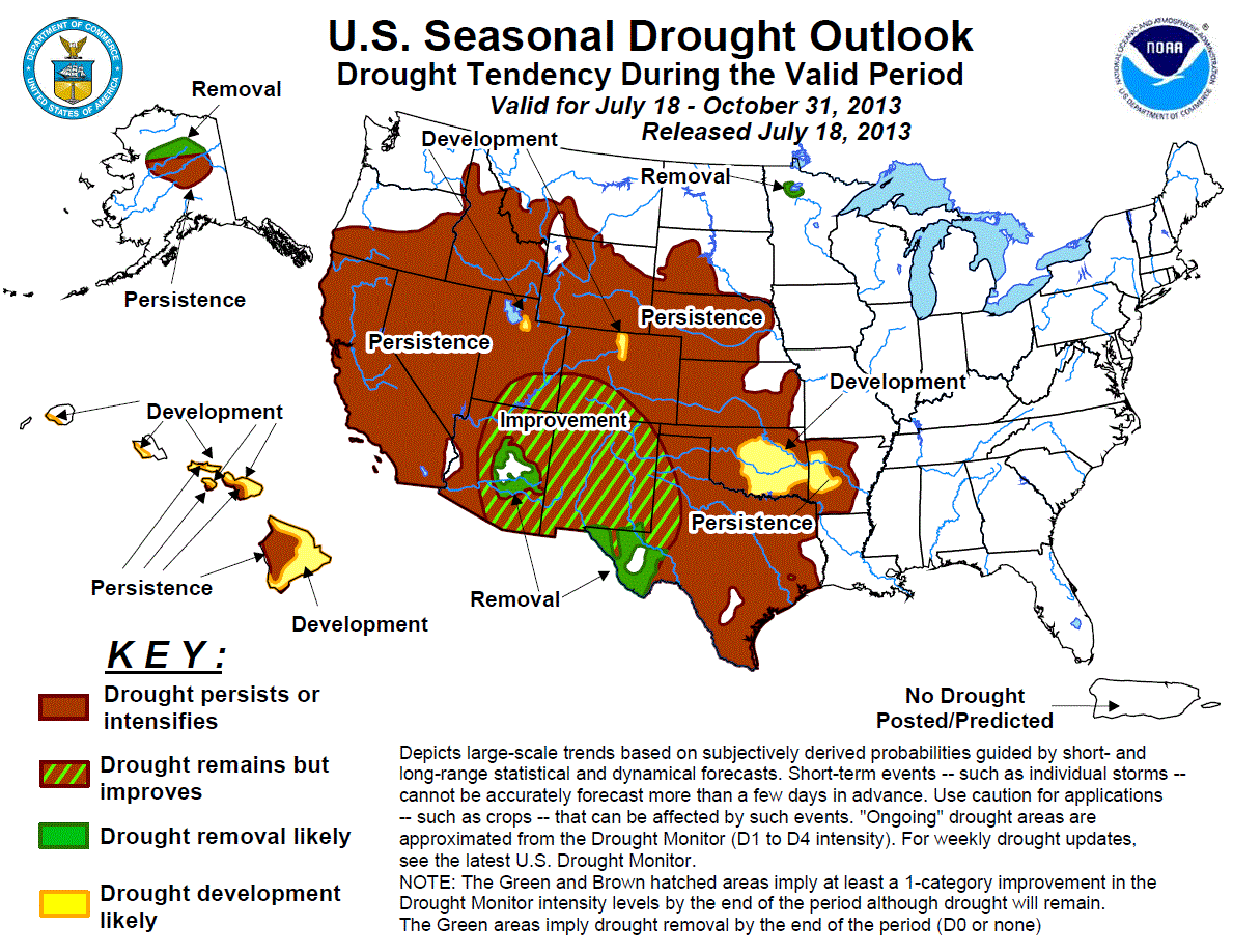
Many of you will probably be interested in the Graphic below. It's an outlook of the next few months for Moisture conditions. I'll discuss the reason and trends at a later time.
season_drought.gif (840×643)

I also want to encourage all of you to visit http://www.cocorahs.org/ . CoCoRaHS is a volunteer network of Weather Observers. Please consider signing up. Northwest Mississippi has a painfully small number of observers, and I want to challenge all of you to at least visit the link. I think you will find that it has some use for you.

A closing thought: If you have a business in the Mississippi Delta and would like to advertise on this site at no cost, please contact me.

Sunday, February 27, 2011

Rain tonight and Monday Morning

I still think my forecast of small rain amounts will verify. The moisture just isn't there to really soak things. Don't be surprised if a Thunderstorm produces intense rainfall, because it should be short lived. Overall Totals should be less than 0.4 inches. The bulk of the Severe Weather Threat for the Mississippi Delta is North. The only problem I foresee is the potential for Microbursts, strong winds brought from the midlevels. A point of concern is also the slight east component to the winds today.

The Warm Front is positioned farther North with this system, where the greatest severe weather threat will exist. Below is a surface Analysis.
90fwbg.gif (750×562)

Below is the observed atmospheric sounding from Jackson, MS this morning.
http://www.spc.noaa.gov/exper/soundings/11022712_OBS/


Notice that the wind barbs along the right side begin as Southeast flow, and gradually turn with height to a more westerly flow. This "backing of the winds" is especially conducive for the development of rotating SuperCells.

Monitor radar and be on the lookout for storms that are linear in structure but begin to "bow." Bowing storms can create an environment of increased wind shear at the mesoscale which can increase the likelihood of Tornado development. Since this is a night-time event, it is imperative that you stay close to  a source of Weather Information.


The high numbers that you see over the Delta are helicity (Wind Shear) forecasts from the Rapid Update Cycle (RUC), a short term mesoscale model used for forecasting Severe Weather. Let's keep an eye on Wind Direction.

Friday, February 25, 2011

Rain Sunday Night, Monday Morning - Clearing Next Week

The Sunday night rain event should be fairly low impact as far as rain amounts. Areas of stronger convection may see higher rain, but I do not foresee any measurable precipitation greater than 0.4 inches happening. Most areas of the Delta will verify around 0.25 - 0.4 inches.

We need to watch out for a Southeast wind on Sunday night, which are more conducive for tornado development.  Severe Weather events at night can be more hazardous due to the low level of awareness. The Storm Prediction Center obviously thinks this will be a fairly high impact event, with most of the risk north of us. Below is the SPC graphic. The forecast soundings indicate small potential for some straight-line winds. A linear storm morphology will more than likely verify, because I dont see a Southeast flow setting up at the surface. The models really struggle at the low levels.


Above is the trough of cold air aloft forecast to affect us and bring some small rain amounts. Clouds associated with the upcoming rain event will limit drying potential for the soil over the next few days. However, next week should become clear. Next rain chances will get thrown in for Friday/Saturday. 

Zonal flow aloft (East-West) should make for a more quiet weather pattern next week. Make sure that your equipment is ready to break some ground late next week. 


Please Comment!

Thursday, February 24, 2011

Severe Weather Materializing

A linear feature has formed along the front.


Threat is thought to be Southeast Arkansas and Northwest Mississippi. We have to watch out for storms that pop up ahead of the main line. Stay close by a source of weather information. I am currently positioned  near Stuttgart, AR just south of the warm front, hopefully in the best environment for Tornado Formation.

MD 126 graphic

The hatched area for the likely Tornado Watch is mainly due to southeasterly winds at the surface.


Pretty interesting boundary on Visible Imagery. Wrong orientation to back the winds though.

Wednesday, February 23, 2011

Thursday's CAPE and Shear Environment

Forecast CAPE (Convective Available Potential Energy is beginning to ramp up over the Delta. Higher CAPE will allow the Thunderstorm updraft to strengthen and cloud tops to achieve much higher altitudes. With the moisture in place right now, don't be surprised to have a few storms race across with high precipitation rates. The storms tomorrow night are going to move really fast, with the potential for some high winds. Tornado threat for the Delta seems moderate at best. The northerly position of the Warm Front puts the Delta under southerly flow. Low-level turning of the winds is very important for tornado formation, something the Delta environment won't have tomorrow. (Unless something really surprising happens) If a Mesoscale boundary can establish itself before the main convection begins, we could see a heightened Tornado risk, but I highly doubt that will happen. A boundary can ramp up Tornado risk by turning the low level winds, effectively increasing Bulk Shear. I'll post the Jackson, MS and Little Rock, AR Soundings and Hodographs in the morning and briefly discuss them before the event starts to unfold.


800 Joules/Kg CAPE in February is considered strong.
wrfUS_0_mlcape_36.gif (800×600)

The Shear Environment is still forecast to be strongest North of the Delta, but that doesn't exempt us from some straight line winds.

EHI is a parameter consisting of Shear and CAPE. A forecaster looks at EHI to determine the best Instability/Shear combination. Interestingly enough, there is an EHI bull's-eye over the MS Delta.
wrfUS_3km_EHI_36.gif (800×600)

February 24th Severe Weather Update

Every Weather Nerd likes to wake up and see this!
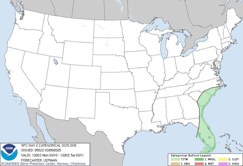
SPC Day 2 0700Z Outlook Categorical
The Graphic you see above was issued by the Storm Prediction Center valid for Thursday. A large portion of the Delta is encircled in the Moderate Risk Area.


The above graphic is a Helicity Forecast from the NAM. Helicity describes the turning of the winds with height. You may also hear this described as "Streamwise Vorticity." Directional shear is very important in the development of Mesocyclones, which produce Tornadoes. Seeing Helicity forecast this high by the models is very impressive.

The clincher for this system is the track of the low. The Guidance is not in agreement on the placement of the Low Pressure. The position of the Warm Front will be a big player in the highest risk areas for Tornadoes.


The European Model forecasts a nice Jet Streak in position over the threat area. The risk area is beneath the right rear quadrant of the Jet Streak, which means the winds are diverging aloft. Diverging winds aloft, means convergence at the surface (Good for Storms.)


Above is a forecasted sounding from the NAM for Thursday night in Greenville, MS. The Models are terrible at forecasting the Thermodynamics for a severe storm event, but something to note is the amount of moisture present throughout the entire column. The green line is Dewpoint, the red is Temperature. The closeness of these lines represents high Relative Humidities. Thunderstorms with strong updrafts can tap into this moisture column and produce heavy rainfall rates. There is no deficit for moisture with this event.

The heaviest rainfall should be in the Northern portion of the Mississippi Delta. The best uplift mechanisms are still well to the north of us, but that doesn't rule out severe weather at all.


I'll post some more information later today as things get fine tuned. Please Comment!

Tuesday, February 22, 2011

Thursday

I've been combing over some of the most recent data, and from the looks of things, most of the lifting mechanism will be North of the Mississippi Delta. It is very difficult to pinpoint things from this range, but it looks as though the Delta may dodge the bullet. Don't plan on working your fields Friday though. Rain chances begin Wednesday night. Thunderstorms will fire during the day Thursday, but the atmosphere will be primed by Thursday evening for the Delta.  This event should be a decent rainmaker, with the Gulf pumping ample moisture into our region. The Storm Prediction Center has addressed concerns of hail with this system as it begins to hammer states in the midwest. I'm just not seeing that for our area.

No need to panic about your wheat getting pounded by hail. I do, however, suggest running some water furrows to make sure things drain well. I'm sure you've all done that by this point though. The moisture profile of this system has the capability for short-lived heavy rainfall in Thunderstorms.

Something to keep an eye on:

The image above is a forecast output for 850 mb Valid Midnight Friday. The red coloring indicates very high windspeeds (The Nocturnal Low Level Jet). High winds above the surface like this can be mixed down during thunderstorms, called a MicroBurst. This usually happens when a dry slot exists in the midlevels. Precipitation falls through the dry air, evaporates, cooling the dry slot rapidly, which subsequently sinks to the surface bringing its momentum with it. I don't see this being a problem since the moisture profile is so saturated, but it is worth noting.

I have read many other opinions of this storm, and some seem to think it is getting slightly hyped. Though that may be the case, and I tend to agree, everyone should stay aware of what is going on. To tie things up, main threat seems to be heavy rain, maybe very small hail in a couple thunderstorms. Nothing that warrants getting all of the equipment under the shed.

Monday, February 21, 2011

Severe Weather Potential for Thursday

The current Buzz in the forecasting world is Thursday's potential for severe weather. I'm going to run through a few things to give a generalized picture of what's going on. 

Following a highly amplified winter pattern, things are shaping up for an active Spring storm season. With that being said, what are the key factors to Thursday's development, and how does it affect your interests? The Storm Prediction Center has issued a mid-range Convective Outlook for Thursday. This can be viewed here: SPC Convective Outlook . You can see from the graphic that the entire Mississippi Delta is encircled in the risk area. So what does this mean for operations on your farm? Not much at this point. 

The Weather Prediction Models can only tell us so much past 3 days. There is significant confidence that an upper level trough will swing through the area. Exact location, timing, and potency are uncertain. Combine the trough with ample moisture and some wind shear and you have a recipe for severe thunderstorms. The upper level trough essentially advects cold air into the upper levels, so when air from the surface rises due to convection, it can continue to rise freely due to buoyancy. (Warmer than surrounding air) Make sense? Think of a beachball in the pool. The low density ball (Warm Air) wants to shoot up above the higher density water (Cold Air). 

Current Wind Profiles look conducive for some Squall Line Activity with localized heavy rainfall given the moisture profiles. We'll be able to iron out some Mesoscale Details (How this will affect your Farm) as the event draws nearer.