Monday, April 11, 2011

Tornado Watch for Northern MS

The Storm Prediction Center has issued a Tornado Watch that includes the Mississippi Delta. This watch is largely due to the track of a surface low and the wind shift as it progresses eastward. The southeast wind really enhances the "hodograph", a graphical representation of vertical wind shear.
WW0128 Radar

Expect the winds to continue backing around of the Southeast.


The Little Rock, AR morning sounding has fairly impressive lapse rates (red line is temperature cooling rapidly with height) that will allow Thunderstorms to strengthen. Main threat now is the Southeast wind causing storms to rotate.

Sunday, April 10, 2011

Interesting Satellite Loop

Seems as if some sort of boundary has formed across the Delta. Notice the linear feature from the MS river extending through Tallahatchie County and the associated wind shift in  Lafayette County. This could be an initiation point for Thunderstorms tomorrow. Rain is still expected as forecast, only timing seems to be off a bit from previous post. I expect rain early tomorrow Morning now, rather than beginning overnight. To view the satellite loop for this image, go here: http://weather.cod.edu/satrad/index.php

Saturday, April 9, 2011

Sunday Night/Monday

The Numerical Guidance has centered on a late Sunday Night/Monday Morning rain event. Accumulations across the Delta will be around 0.5 inches. A quick look at some Radar and Visible Satellite Imagery Monday morning will tell us more about where convection is taking place, and where higher rainfall amounts can be expected. At this range it is impossible to forecast the exact location of Thunderstorms at the Micro-scale (County Level).  There is a small body of research that suggests convections occurs along thermal boundaries created by soil, vegetation, hydrologic features, etc... I'll discuss that later in detail and include a few links to interesting papers.

This time of year mechanical forcing in the atmosphere (Dynamics) is still the main source of rainfall, not convection (Thunderstorms), so it is beneficial to follow the movement of the atmosphere and track where it will act to balance itself; after all, weather is nothing more than the air around you trying to reach equilibrium.

Below is a forecast graphic from the Canadian Ensemble Prediction System. The red numbers represent "members" of the ensemble. Clustering of members increases forecast confidence. Notice the cluster to the west of the delta valid for 12 hours before we expect any rain. The model places us inside the 5 Millimeter (0.2 Inches) line during the Sunday Night/Monday morning time period.
12h precipitation accumulation
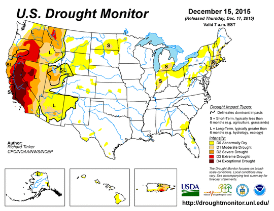
Though the rains right now are most likely frustrating to you, it is important to keep in mind the drought conditions. Things won't take long to dry up since temperatures will be in the mid 70's next week. 
United States Drought Monitor
Climatologists are expecting ENSO to go neutral as we move into May and June, which means we will be in neither La Nina or El Nino conditions. 


Tuesday, April 5, 2011

Clear this Week, Rain during the Weekend

Grain Farmers, Great article from the Delta Farm Press regarding Biofuels can be read here: http://deltafarmpress.com/management/biofuel-mandates-increase-demand-corn-soy-oil

Models are in good agreement for a clear week with progressively warmer temperatures. You should have an opportunity this week to get in the fields and work before another disturbance affects the Delta Sunday Night/Monday. Below is a forecast graphic for Early next week. You can see a Cold Front just to our West.
Day 7 Fronts and Pressures

A few more Surface Observation stations have recently gone online in the Mississippi Delta. This may be especially useful for you when monitoring wind conditions for Spraying. You can see the Surface observations here: http://www.rap.ucar.edu/weather/surface/displaySfc.php?region=lit&endDate=20110405&endTime=-1&duration=0
For help interpreting this data, contact me by commenting on this post.

Forecast graphic below depicts Warm Air Advection from the Gulf Friday night. With a Low deepening to our west and the flow off the Gulf of Mexico, this won't last long without some showers which are expected early next week.

wrfUS_2_temp_84.gif (800×600)

Monday, April 4, 2011

Severe Weather Update

WW0091 Radar

SPC has issued this Tornado Watch, still not overly concerned with Tornado threat, but rather high winds. The surface flow will limit circulation. Keep an eye on current radar for "bowing" features which indicate high winds. Also watch for the erosion of precipitation behind the main line, which can indicate high winds. Notice that the squall line is followed by lighter stratiform precipitation. This is especially dangerous for a high wind threat. Many Derecho's (Wind Events) have been associated with lines similar to this.

lit METAR plot

Squall Line to affect the Delta today

SPC Day1 1300Z Outlook Categorical


The Storm Prediction Center has issued a Moderate Risk for the Delta today. I expect a linear feature given the wind profile with heavy rain. Expect 2 inches in the strongest Thunderstorms.


The SPC has issued a Public Severe Weather Outlook that I have posted here for your convenience. 

ZCZC SPCPWOSPC ALL
   WOUS40 KWNS 040905
   ALZ000-MSZ000-TNZ000-041800-
   
   PUBLIC SEVERE WEATHER OUTLOOK  
   NWS STORM PREDICTION CENTER NORMAN OK
   0405 AM CDT MON APR 04 2011
   
   ...WIDESPREAD SEVERE THUNDERSTORMS EXPECTED OVER PARTS OF THE LOWER
   MISSISSIPPI VALLEY INTO TENNESSEE VALLEY TODAY INTO TONIGHT...
   
   THE NWS STORM PREDICTION CENTER IN NORMAN OK IS FORECASTING THE
   DEVELOPMENT OF WIDESPREAD DAMAGING WINDS AND POSSIBLY A FEW
   TORNADOES OVER PARTS OF THE LOWER MISSISSIPPI VALLEY INTO TENNESSEE
   VALLEY TODAY INTO TONIGHT.
   
   THE AREAS MOST LIKELY TO EXPERIENCE THIS ACTIVITY INCLUDE
   
          NORTHERN ALABAMA
          NORTHERN AND CENTRAL MISSISSIPPI
          WESTERN AND MIDDLE TENNESSEE
   
   ELSEWHERE...SEVERE STORMS ARE ALSO POSSIBLE FROM THE UPPER OHIO
   VALLEY TO THE GULF COAST STATES.
   
   A STRONG UPPER-LEVEL STORM SYSTEM WITH ASSOCIATED JET STREAM WINDS
   GREATER THAN 100 MPH WILL PROGRESS FROM THE GREAT PLAINS THROUGH THE
   OHIO AND TENNESSEE VALLEYS AND GULF COAST STATES TODAY AND TONIGHT. 
   A COLD FRONT WILL ACCOMPANY THE UPPER-AIR STORM SYSTEM WITH THIS
   FEATURE PROVIDING THE FOCUS FOR SEVERE THUNDERSTORMS IT SURGES
   EASTWARD THROUGH THE REGION.  
   
   THROUGH THE REMAINDER OF THE MORNING...EXPECT LOCATIONS FROM THE MID
   MISSISSIPPI VALLEY SOUTHWESTWARD INTO ARKANSAS...EASTERN TEXAS AND
   LOUISIANA TO BE IMPACTED BY A FEW SEVERE STORMS.  BY AFTERNOON...THE
   FRONT WILL ENCOUNTER A WARMER AND MORE HUMID AIR MASS STREAMING
   NORTHWARD FROM THE GULF OF MEXICO THROUGH THE LOWER MISSISSIPPI
   VALLEY INTO TENNESSEE VALLEY.  THIS WILL RESULT IN A MARKED INCREASE
   IN SEVERE THUNDERSTORMS ALONG THE COLD FRONT.  THESE STORMS WILL BE
   CAPABLE OF WIDESPREAD DAMAGING WINDS AND PERHAPS A FEW TORNADOES AS
   THEY ADVANCE ACROSS THE TENNESSEE VALLEY AND GULF COAST STATES TODAY
   INTO TONIGHT.
   
   STATE AND LOCAL EMERGENCY MANAGERS ARE MONITORING THIS DEVELOPING
   SITUATION. THOSE IN THE THREATENED AREA ARE URGED TO REVIEW SEVERE
   WEATHER SAFETY RULES AND TO LISTEN TO RADIO...TELEVISION...AND NOAA
   WEATHER RADIO FOR POSSIBLE WATCHES...WARNINGS...AND STATEMENTS LATER
   TODAY.
   
   ..MEAD.. 04/04/2011
Notice how the Solid Red Line (Temperature) Cools rapidly with height. This is conducive for severe weather.


Current Surface Observations reveal a Southwest Flow, which will limit rotation of storms. 
lit METAR plot