Thursday, March 31, 2011

Interesting Article

Check out this article from the Delta Farm Press.
http://deltafarmpress.com/government/renewable-fuels-present-tremendous-opportunities

Maybe a few showers tonight, nothing high impact. Most of the rain is north of Delta right now. Next week is shaping up to be fairly active as well, with perhaps a few days clear enough to work. There is a severe weather risk shaping up for Tuesday/Wednesday.

gfsUS_2_temp_108.gif (800×600)

You can see the forecast Low pressure situated in the Northeastern Portion of Oklahoma, with high temperatures and  Southeast winds forecast for Mississippi. The map is valid for Monday afternoon/night.

Wednesday, March 30, 2011

Rain... How Much?

Though recent rains have kept many of you out of the field, recent accumulation will help to ease the drought. The Delta is already starting to see the effects of convection. A storm system will come through, and rain amounts vary across the region. Expect to see this more and more as we move into Severe Weather Season. On Thursday most of you will see more rain. In the longer range, the next rain event will come Monday/Tuesday. I know all that most of you are waiting on is that "High Pressure" to move in. I wouldn't expect a long span of days with clear weather this time of year, but that is nothing that I have to tell you. If I foresee a window of opportunity coming up I'll make sure to post. 


Monday, March 28, 2011

Dreary Weak

I've been noticing that graphics are updating in my old posts which might make them confusing if you read them a day late. I apologize for that problem; I'm in the process of fixing it. 

Hopefully most of you are not shocked by the brief "return to winter" if you read my posts last week. Get ready for another round of Thunderstorms Tuesday night and some other rain chances through the week. Many of you may be frustrated if you are trying to get field work done, but these rains are coming at a great time in order to relieve drought and recharge the shallow alluvial aquifer that the Delta pulls its groundwater from. 

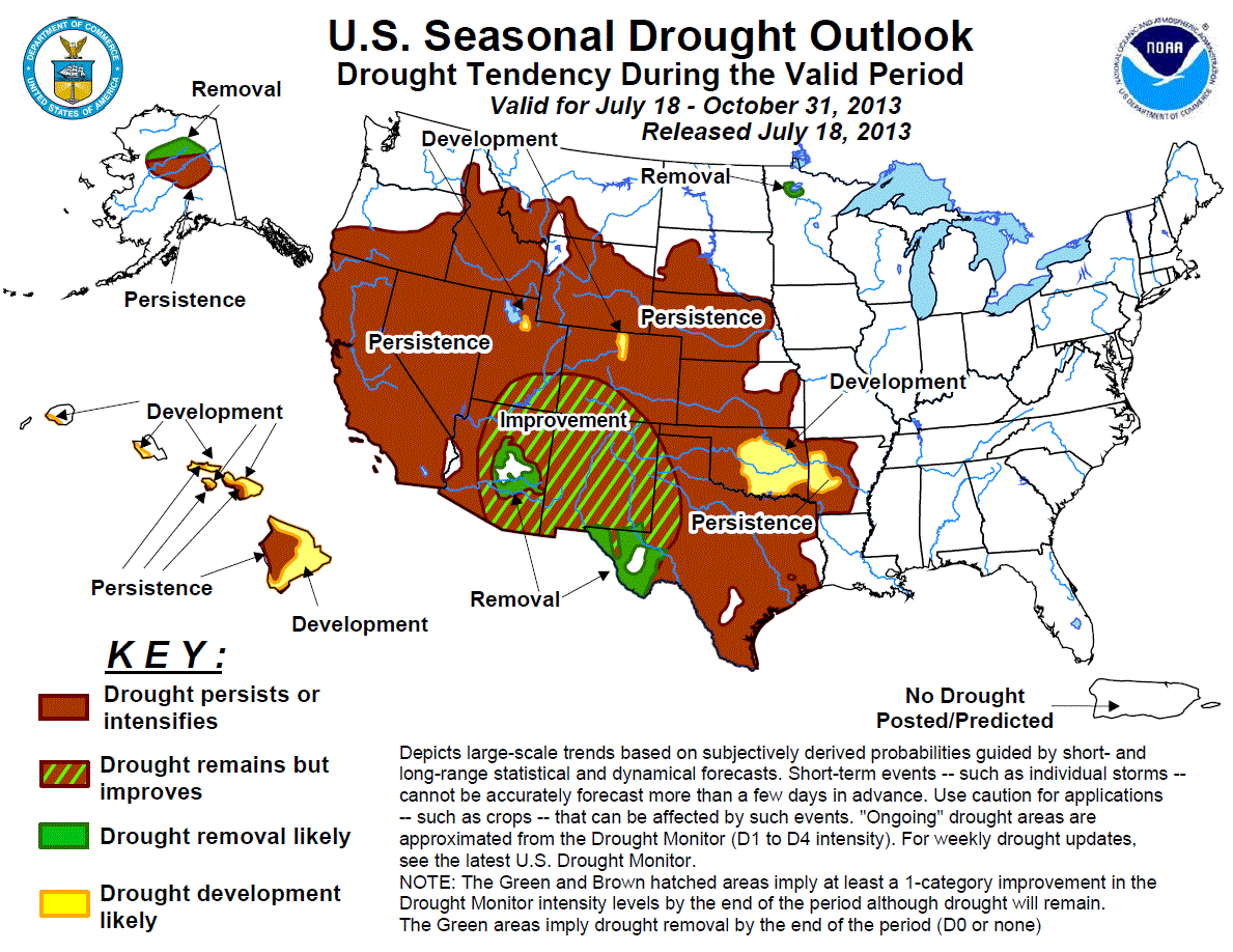
season_drought.gif (894×690)

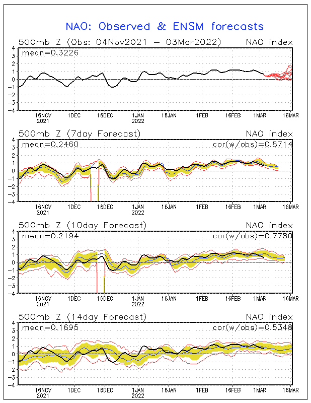
nao.sprd2.gif (600×800)

The NAO is forecast to go positive, so we can expect springlike conditions over the next few weeks. Without the blocking in place, colder air cannot "Lag" behind in the Southeast. For an explanation of NAO, check out some of my archived posts or comment with your questions. 

Friday, March 25, 2011

Storms through the Weekend

Pretty good bit of rain North of us right now. There is a slim chance of rain tonight, but it would be nothing to affect your plans during the day today. The bulk of rain will begin late tonight and all day tomorrow. Severe potential will be strongly correlated to the track of the Low pressure and placement of the Warm Front. I'll post tomorrow once moisture and thermal boundaries for thunderstorm initiation are in place.
southeast.gif (800×600)
Forecast Sounding for KGWO (Greenwood). Note the absence of a warm layer, and steady cooling with height (Red Line). There is ample energy for convection. 
Moisture will have to be diagnosed at the Mesoscale during the morning hours tomorrow. I have seen the models really struggle with low-level moisture so I'm not going to waste time discussing that on this post.  Southwest surface winds will limit severe potential tomorrow. 

In the Long-Range....
I still look for next week to be much colder. The European and US based Global Forecast System are in good agreement for a chilly Thursday/Friday. 
ecmwf_850_temp_168.gif (800×600)
European Model (Add 25 Degrees for a high temperature forecast for Thursday Afternoon)
gfsUS_2_temp_174.gif (800×600)
US Based Global Forecast System for late next Week
There have been hard freeze warnings north of us in Tennessee recently. With the cold air forecast to dip down lower into our region next week I wouldn't be surprised to see some mid 30's overnight low temperatures, but we are still too far out to definitively call for a freeze. 

Thursday, March 24, 2011

Colder Look and some Rain in the Extended Forecast

I expect to see a colder look over the next week or two with the NAO forecast to go negative. I briefly discussed NAO in yesterday's post. I have fairly good confidence in a dynamically driven (Cold Front) rain event Mid/Late next week. The Ensemble Prediction Systems (Many different versions of a model "tweaked" with different physics) are in good agreement for a colder look and the NAO is negative; I don't see why that wont come to fruition. I am concerned for recently planted corn, not for a freeze risk, but more so from a soil temperature standpoint. 

I'll post tomorrow on the Severe Weather Risk for this weekend.
814temp.new.gif (719×668)
Temperatures forecast to be below normal 8-15 Days from now. 

gfsUS_2_temp_168.gif (800×600)
GFS (Global Forecast System) Valid for Thursday Morning
Ensemble Prediction for the 0 Degree Celsius 850 mb (1 Mile High) Pressure Surface

Wednesday, March 23, 2011

Rain this Weekend, A Possible Freeze in the Long Range

Hopefully most of your fields stayed dry today. I have glanced at radar a few times and most showers are staying well north of Mississippi. I went with my gut and against all the model guidance by forecasting no rain, so I hope that some of you were able to manage and plan your operation better. Fairly good confidence in the weekend forecast for some rain Saturday Night/Sunday Morning. There is a severe weather threat early next week as well, which I won't discuss on this post, but can potentially bring some higher rainfall amounts.

With all the preparation for corn being done right now, I think it is important to highlight the current pattern in weather for the South as well as bring up a few other points. We are currently in a phase where the NAO (North Atlantic Oscillation) is forecast to go negative. The NAO is a teleconnection using observed pressure anomalies to predict the flow pattern over North America. The negative phase of the NAO has a strong correlation with a high-amplitude pattern (Fronts, Low Pressure), while the positive NAO typically means more of a zonal flow regime (East-West Flow, Calm Weather). A negative NAO during this time of the year is of some concern since crops are beginning to be planted. The negative phase is more likely to allow cold air to seep down into the South and linger, increasing the likelihood for a Freeze.

NAO Forecast

The European Model for 7 Days out is somewhat ominous, especially knowing at this point that the NAO is forecast to trend negative. I'm saying all this to warn you if you are thinking of planting corn early. There have been freezes in Mississippi as late as the end of April. For those of you with corn in the ground already, weekend rains should be enough to get it up, but it should still be just before germinating  when and if the freeze occurs. The only real problem should be stunted growth since the soil is going to have to warm back up. I am going to keep an eye on this and will post more. If cold air hangs around behind the Thunderstorms early next week and there is clearing through the night with calm winds, I wouldn't be surprised to see temperature drop to the mid thirties to freezing in some northern locations.

ecmwf_850_temp_168.gif (800×600)
European Model (Surface Pressure and Mid-Level Temperatures) Valid for Tuesday Night

Tuesday, March 22, 2011

Wednesday's Rain Chances and Friday/Saturday

Made some changes to the layout so the posts will be easier to read. I'd love to hear your opinions, you can easily make a comment at the bottom of each post. 


Weak Cold Front to the West of Mississippi
The Temperature Gradient associated with this fron is very weak, so the mechanical forcing for Rain on Wednesday will be almost non-existent. You may also notice the Southern Flow across the state. This setup is transporting Gulf Moisture into the area; Dewpoints are relatively high. 


If a few showers pop up, accumulation will be insignificant. There will be no Thunderstorms. I'm still forecasting no rain, although I am not extremely confident given that there will be moisture in place and a lifting mechanism coming through (Front). 

The next threat of rain is Saturday, another weak setup with low accumulations. 

Monday, March 21, 2011

Clear all Week or Rain Wednesday?

A weak frontal passage Wednesday will affect the Mississippi Delta Wednesday. The Weather Service has thrown in some 20% - 30% Rain Chances, which affects all of you as you are trying to get the fields ready for planting. I am fairly confident that there will be no rainfall accumulation. 

The next ran chances are at the end of the week. I will post a long range forecast pertaining to that even later today. 

A strong cap (Layer of Warm Air Aloft) will limit convection. You can see how the red line (Temperature) sharply increases with height, then begins to cool again. 


The graphic below is an Ensemble forecast from the Canadian Regional Model. The clustering of red numbers (Different Versions of the Model) indicate forecast confidence. Most all of the members are well north of the Delta, which means that the rain threat is to the north. 

12h precipitation accumulation

Something worth noting is the Warm Air Advection which is being augmented by position of a Low Pressure near Iowa, and a High Pressure south of Florida. This setup will pull in Gulf Moisture.

gfsUS_850_temp_48.gif (800×600)


Friday, March 11, 2011

Optimum Dates for Planting Corn

Many of you are probably preparing to plant Corn when the soils dry. What are the risks of planting Corn early? What does the soil temperature actually need to be?

The article below is from the Mississippi State Extension Service:


The standard guideline for determining earliest planting date is when morning soil temperature at a 2 inch soil depth is 55º F or 50º F at a 6 inch soil depth. Planting before the soil temperature is warm enough for germination greatly increases the potential for stand failure.
Soil temperature may vary depending upon soil texture, slope, color and amount and type of crop residue. Thus, randomly measuring soil temperature with a thermometer within a field should provide a reliable indicator of desirable conditions for stand establishment.
Corn produces highest yields when planted within 4 - 5 weeks after soil temperature is warm enough for germination. This has historically corresponded with the following calendar dates:
Geographical Region of Mississippi:
Coastal : February 25 - March 15
Southern: March 5 - April 10
Central: March 15 - April 20
Northern: March 20 - April 25
Although early planting is a critical component of successful corn production, planting corn extremely early (substantially before suggested dates), even if soil temperatures are warm, provides little if any agronomic benefit, while increasing risk of stand failure. Although the growing point of a corn plant remains underground until about the V6 growth stage (12" tall), temperatures cold enough to freeze the soil can kill seedlings. Falling soil temperature also substantially increases the likelihood of stand failure, since seedling vigor is closely correlated to soil temperature. Extraordinarily early planting enhances maturity very little, because corn growth rate is correlated to temperature, and heat unit accumulation (GDD 50) is historically very low during early March.


After checking the sparse network of soil temperature observations in the Delta, I am seeing numbers around 50 Degrees in the top 2 inches of soil. Planting Corn before we see an extended period of 55 Degree topsoil temperature puts your crop at a big risk for improper germination.

Thursday, March 10, 2011

Friday's Low Temperature

There has been some concern the past few days from the Jackson NWS Office about a freeze Friday night. A freeze this time of year is low impact since no one is putting seed in the ground, however I want to mention it. My forecasted Low for tomorrow is 34, which does agree with the National Weather Service.

When Weather Prediction Models run, the model output is analyzed statistically and compared with climatology. The result is MOS, or Model Output Statistics. MOS is freely available but cannot be used blindly as a forecast tool, as it has many limitations. Many different versions of a model, or "Perturbations" are also run each day. The "Perturbations" are put together to produce an "Ensemble" Forecast. Many times the Operational version of a model (the one that is in widespread use to produce a forecast) will vary from the Ensemble. Also, if a forecaster sees that there is high agreement among the Ensemble "Perturbations" , forecast confidence increases. In the case of Friday night, there is good agreement for an above freezing Low Temperature.

uh2spd.gif (800×600)
Nice East/West "Zonal" Flow behind the recent Heavy Rain Event. Notice the trough to the West near California. This can potentially bring more Rain to the Delta early next week. We'll keep an eye on it. I foresee the Sunday/Monday Rain Chances being negligible unless the Moisture profile strengthens.


Notice how much the Dewpoint is depressed from Temperature. This is a very low Moisture forecast sounding for Greenwood, MS. This image is valid for Sunday Afternoon.

Wednesday, March 9, 2011

Answering the Big Question: When can you get in the Field?

I anticipate that many of you saw much more rain from yesterday and last night's event than I forecast. I attempt to be conservative yet accurate since I'm trying to give an outlook for a region. In the mind of the Farmer, a 2 inch rain versus a 4 inch rain has the same effect during the Spring. Both amounts keep tractors out of the field. With this in mind, knowing that rainfall would be variable across an area, I threw out the number 1.5 inches. I've checked and some areas saw near 4 inches where Strong Thunderstorms tracked across. I want to be accountable for my actions, and I do apologize if you were negatively affected by my information.

Below is what we want to see for quiet weather. This map is a forecast for the upper levels, where the "Jet Stream" is found.
wrfUS_250_spd_84.gif (800×600)


Looking to the Long Range.... Below is a forecast output for early next week from the European Model. I'm suspicious of the Low along the Gulf Coast. I don't think that we'll see that materialize that far South. The trend looks to be quieting down, but I don't want to rule out some light showers next week. Even when there isn't a major forcing mechanism like a front, Warm Air Advection from Southerly flow can produce showers.

ecmwf_850_temp_168.gif (800×600)

The Graphic below is an outlook for the next 8-14 days. You can see that we are in the unshaded area which means that the upcoming weather will be typical for this time of year, 0.4 inches of rain or less. This is not to say 2011 will not be atypical, rather it is a prediction of the future based on the past, an Analog approach.

814prcp.new.gif (719×668)

From the Climate Prediction Center:

THE SEASONAL PRECIPITATION OUTLOOK FOR MAM (March April May) 2011 FAVORS BELOW-MEDIAN 
PRECIPITATION AMOUNTS FROM CENTRAL AND SOUTHERN CALIFORNIA EASTWARD THROUGH THE 
SOUTHERN HALF OF THE ROCKIES, THE CENTRAL PLAINS AND MUCH OF THE SOUTHERN 
PLAINS, CONTINUING EASTWARD ACROSS THE GULF COAST STATES AND SOUTHERN ATLANTIC 
COAST STATES. 

Tuesday, March 8, 2011

Severe Weather

The Storm Prediction Center has increased the level of concern for severe weather today. Heavy Rain for the Delta with accumulations around 1.5 inches. If it stops raining where you are, do not assume that the event is over. We are just now beginning to see the passage of the Warm Front. The Cold Front will pass through the night bringing heavy rain.

Surface Analysis. Low Pressure tracking near Arkansas typically brings these types of setups for Mississippi. You can see both fronts draped across Texas. Lots of Southeast Wind across the State today, perfect for Supercell Development.


Below is a Hi-Resolution Satellite Image from earlier this morning. You can see the shadows cast by storms tops in South Mississippi.


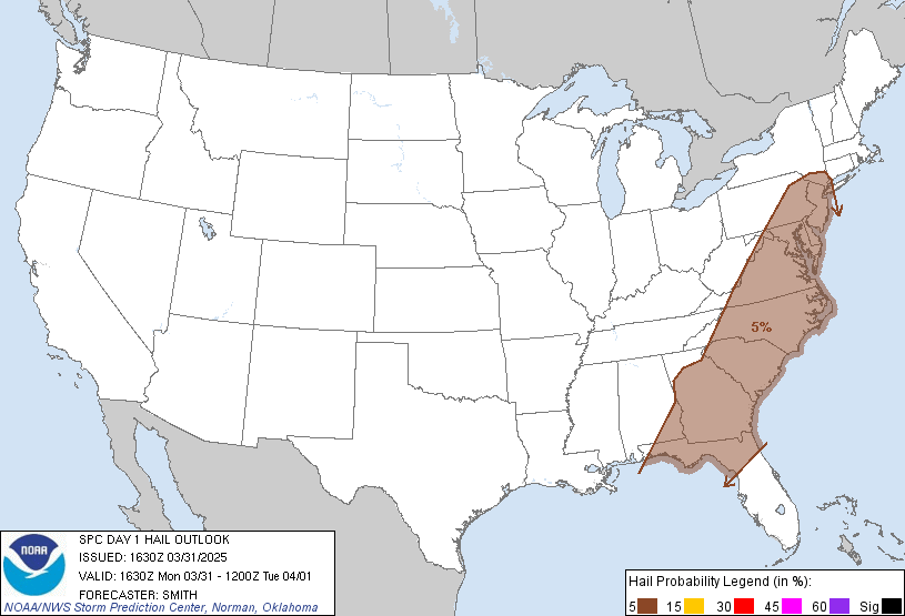
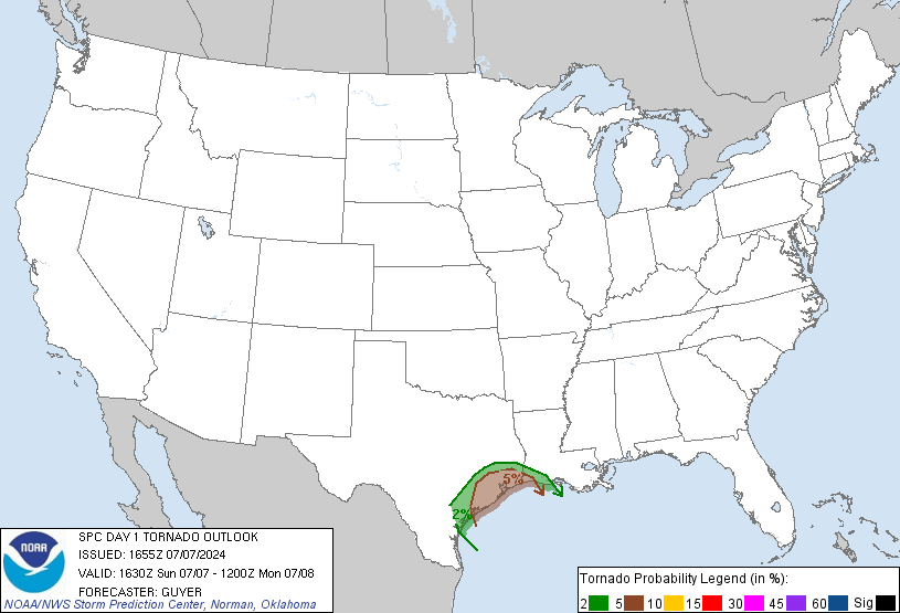
The Mississippi Delta is encircled in the 15% probability for hail. The main Tornado threat is south of us, with a 15% probability in southern Mississippi. Lack of moisture and instability will keep us relatively safe from anything extremely severe. The hail threat is not something to overlook, but since the winter wheat hasn't headed out yet, damage such not be very bad. I am not saying that hail is eminent, I am simply outlining the risk.

Hail Probability
day1probotlk_1630_hail.gif (582×408)
Tornado Probability
day1probotlk_1630_torn.gif (582×408)

Monday, March 7, 2011

Tuesday Rain

Thunderstorms tomorrow across the Delta. Another round of heavy rainfall is in store. I'm a bit concerned with the threat of severe weather seeing the forecasted wind profile, but the main thing to watch out for is heavy rainfall during the night time hours if you are on the road. I'll update tomorrow morning with some more details. We've got some clear and cool nights ahead of us.

The past few days have served to remind us Spring is not in full swing. Climatologically, the last freeze in most areas of Mississippi is mid-April, which is definitely something to keep in mind with planting season right at the doorstep.

So when will Spring get here? And how long will the cold air behind the front linger? These questions are answered using a variety of tools and experience. One widely used tool for long range forecasting is the teleconnection. Most of you are probably familiar with SOI (Southern Oscillation Index). The positive phase of SOI is associated with La Nina, while the negative phase is associated with El Nino.

At the top of the graphic below you can see that the NAO (North Atlantic Oscillation) is in the positive phase (above the baseline) and is forecast to go slightly negative (below the baseline.) The NAO serves as a proxy for blocking (High Pressure) to the North of the United States. When the NAO is negative, the blocking is in place, so weather systems tend to linger. When the NAO is positive, we see a more progressive pattern. We are currently in the positive phase, so we should see this cold air modify quickly with things warming up until another shot of cold air.

nao.sprd2.gif (600×800)

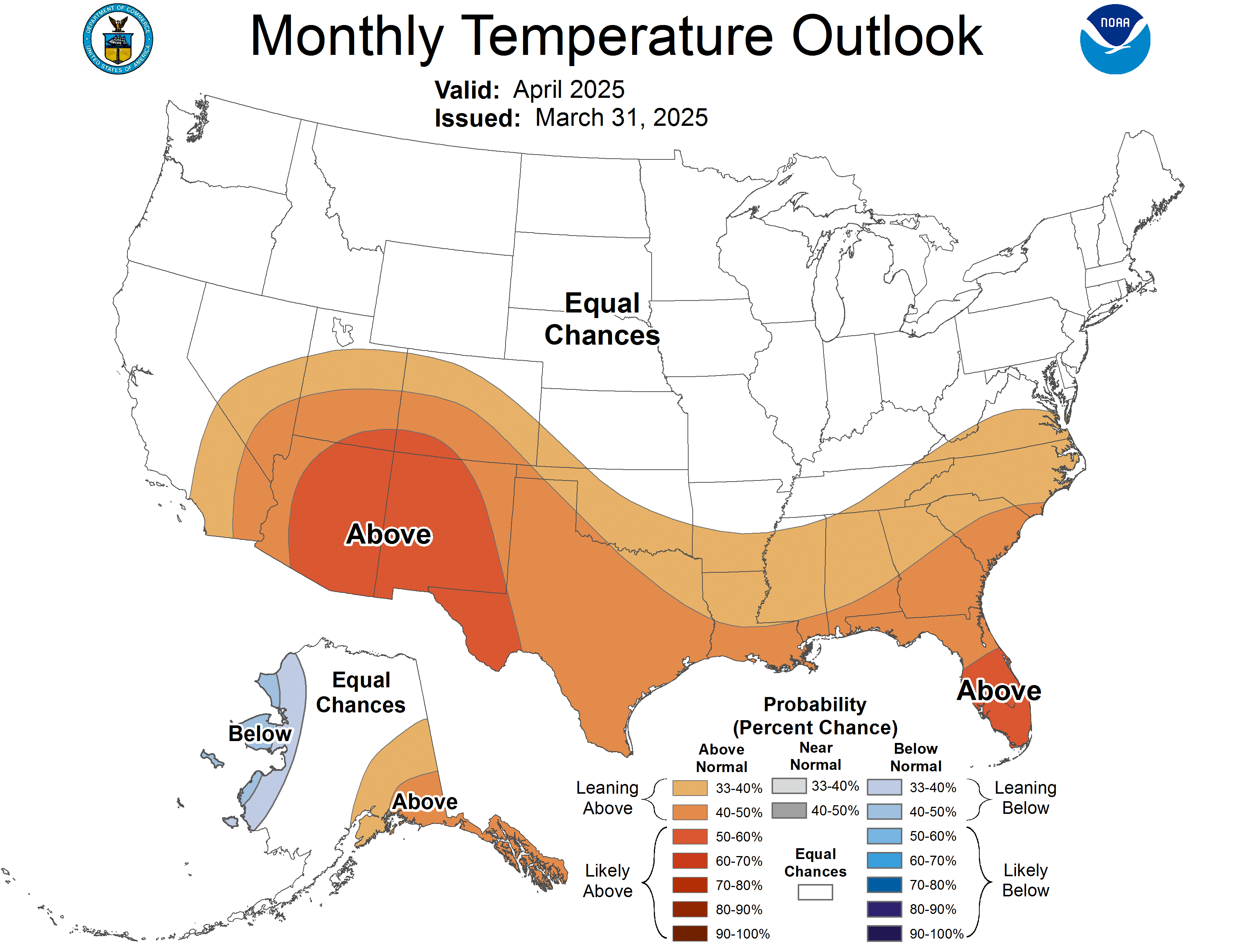
Graphic Below is from the Climate Prediction Center, which forecasts that we will see a warm up within the next month. Those of you with Spring Fever should like this graphic. The reds represent temperatures "above normal" for that time period. This forecast makes sense with the breakdown of the jet stream pattern typically observed during the winter months.

off15_temp.gif (719×668)

Sunday, March 6, 2011

More Soaking Rain on the Way

It's looking like Tuesday night may be a re-run of this past weekend. Periods of heavy rain will likely begin  in the late afternoon to night time hours on Tuesday and progressively move out by mid-day Wednesday.

SPC Day 3 0830Z Prob Outlook
The Storm Prediction Center has issued an Outlook valid for Tuesday. This Outlook means that there is high confidence that convection will occur and initiate Thunderstorms with this event, which can drive up precipitation rates and total amounts. The Models are already picking up on mild levels of CAPE (Convective Available Potential Energy) , and only a few things have to line up for CAPE to be much higher on the day of the event.

Below you can see the Mid-Level Trough and Surface Low in Missouri.

Thursday, March 3, 2011

Friday/Saturday Update

Don't make plans to get in the fields anytime soon. Rain accumulations will easily achieve 1 inch in places. The entire Delta is more likely to see 0.5 inches to 0.75 inch totals. The bulk of rain will begin Friday afternoon and will begin to end Saturday afternoon. I'm not ruling out light showers preceding the main event, but it won't be anything that will actually affect any of your plans, so it is irrelevant.

The graphic below is forecast rain amounts from the NAM (North American Model). The NAM is picking up on higher rain amounts in the North Delta. The Hydrometeorological Prediction Center has bought into this solution and has adjusted rain amounts accordingly. I'm not so fast to agree with model output since these storms will be heavily affected by the amount of Heat available in the environment. The fact that the models are forecasting high rain amounts is of concern since they don't do a good job of modeling convection, which will be a big player in producing intense rainfall rates.

wrfUS_0_prec_60.gif (800×600)

HPC Rain Forecast Below


Last week's storm system dumped large amounts of rain North of the Delta which has runoff into the Mississippi River and caused the River to approach flood stage in many areas. Below is a graphic from NWS Jackson, MS. The likelihood for heavy rains this weekend will only amplify this.

image_full2.gif (1272×894)

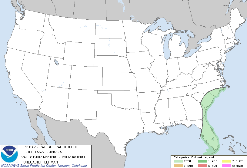
The Storm Prediction Center has included the Delta in the Day 2 "Convective Outlook." The saturated moisture profile coupled with an environment forecast to be unstable has introduced the likelihood for heavy rainfall. I expect the heaviest Rainfall Rates on Saturday afternoon, when forecast potential energy is at its peak (CAPE).
SPC Day 2 0700Z Outlook Categorical

Wednesday, March 2, 2011

Will Saturday's Thunderstorms Be Severe?

A very important factor for the strength of storms that will develop on Saturday is the timing and position of the Low. Warm Front position is critical in a Severe Weather Forecast. The risk area's position relative to the surface Low has everything to do with the development of rotating storms. Winds tend to bend eastward as they enter the surface Low, which in turn steepens Helicity Values. Helicity is a product that gives forecasters a look at the speed and directional wind shear within an environment. Storms that develop in an environment with substantial directional shear are much more likely to rotate. Rotating "Supercells" are responsible for producing Tornadoes.

The strength of Severe storms is dependent on the mechanical forcing (Dynamics) and the potential energy available in the environment (Thermodynamics). Thermodynamics are not handled well by the models, so when forecasting a Severe Event from days out, I focus on the mechanical forcing (Dynamics). The dynamics are in place for some activity this weekend.

The National Weather Service Office in Jackson, MS has bought in to a more Southerly Solution for the low track, which ramps up the Severe Weather probability. It's just too early to call for Doomsday when so much depends on Small Scale (Mesoscale) processes during this time of the year. It's February, so the vertical temperature gradient is not very strong. What I'm saying is that the sun needs to come out and really heat things up on Saturday for Severe Weather to get going. If the Warm Front establishes clouds and keeps the surface heating down, we can say goodbye to the Severe Threat.

Challenging Weekend Forecast...Very Cold Air behind the Front

Clouds will begin to build Thursday night and all day Friday. There are some small rain chances on Thursday night, but nothing that will do anything to upset anyone's plans with very small accumulations. The heaviest rain will begin Friday night and last through much of Saturday. Forecast accumulations are near 1 inch. There is quite a bit of uncertainty with this forecast and I will keep updating as things materialize. The GFS model (Global Forecast System) seems to be converging moisture over the Delta, which is making it blow up with the Rain amounts. I think that is an error, so I'm putting my neck on the line at this point and saying we won't see 1 inch rainfall over a broad area.  Expect the winds to shift out of the South later this week at about 10 mph. My preliminary feeling is still to undershoot model forecasts and go with 0.5 inches and higher amounts in Thunderstorms up to 0.75 inches.

Really Cold Air behind this system, cold temperatures shouldn't last long though.

The image below is valid for 6 AM Friday to 6 AM Saturday. This does not mean that rain will begin at 6 AM, rather it depicts forecast precipitation accumulations.


Below is the forecasted "shortwave trough" in the upper levels of that atmosphere that will bring rain and possibly some severe weather to the Delta.


Southeast Flow bringing ample moisture into the environment.

Tuesday, March 1, 2011

Wet Weekend with Cold Nights

I'm sure that most of you have begun seeing rain chances pop up. Hopefully we can do a bit better than "probabilities" with this event. Rain accumulations on Friday will be insignificant. The Bulk of the rain will arrive Saturday. Currently there is one Model really blowing up with Rain amounts, but I am skeptical from this far out. Expect a wind shift out of the Southeast later in the week bringing in moisture as a precursor to the Rain Saturday.

I've posted regarding this topic before, but the driver for the next rain event is an Upper Level Trough of Cold air. You can see this pictured below.

gfsUS_500_spd_96.gif (800×600)

Thunderstorms require 3 main ingredients: Moisture, Lift, and Instability. In the Delta, we typically have Moisture and Instability but an absence of Lift. Very small scale sources of Lift during the Summer are responsible for the apparent pop-up nature of Thunderstorms. A lifting mechanism can be a thermal boundary created by any number of phenomenon, or outflow from an old Thunderstorm. The problem with Convective forecasting is not diagnosing Moisture and Instability, but rather the lifting mechanism. Radar and Satellite must be scoured to locate boundaries. More often than not these boundaries are not visible until hours before the event.